Sunday, August 26, 2007

Glacier Wrap Up

After getting out of the back country, we opted to get some food before retrieving the car. After stuffing ourselves full, we retrieved the car and drove back to the east side of the park to grab a campsite in one of the established campgrounds. As we drove through the Rising Sun campground checking out campsites, I saw two rangers standing and conversing.

After scouting, we circled back around to get our chosen site and when we passed the rangers again I noticed they were looking up towards the hill the campsite backed up against. So as we started to set up the tent, I told Jill "There has to be something over there, they are definitely on alert about something."

I grabbed my camera, threw my big lens on and then headed that direction. Getting closer, I heard people talking and then saw exactly what I suspected, a bear. This black bear was CLOSE to a tent site, but he was just munching on bushes and berries and showed no interest in any of the people. Nevertheless, the rangers have to chase the bear away to keep any incidents from occurring.

Don't mind me, just grabbing a quick snack


The bear excitement quickly dissipated as the ranger brought out the bean-bag shotgun. She never even had to fire a shot, simply the sound of her loading it up was enough to entice Yogi to scurry up the hill out away from the campsite. I'm guessing he'd been subjected to a bean bag to the butt before.

The next morning, we woke up and headed back south to Yellowstone and then Grand Teton to split up the big drive again. Despite our relentless searching, we failed to find any more grizzlies in Yellowstone, evidently just missing a mother and two cubs. We did get to see a huge bull moose lounging near a stream with a huge crowd of onlookers snapping pics.


A quiet night in Grand Teton, an early morning and 8 hours of driving had us back to Boulder County by 2 or 3pm on Saturday. Tired, definitely ready to be out of the car, but quite happy to have had another chance to get out and take hold of life helps us cope with the mundane life of us holding down desk jobs.

What's up next? Yosemite seems like the next big trip, but we might think about the 30 mile Teton Crest Trail too given Grand Teton's relatively close proximity to us. And of course we've also got Rocky Mountain in extremely close proximity, and we are far, far away from exhausting all it has to offer.

Glacier Backpacking Trip - Day 3

Gunsight Lake was an improvement in just about every way over Sperry (where we camped night 1), except for the "nuisance" deer we had been warned about. Who knew there was such a thing? Well I'm here to tell you that they do indeed exist, and frequent Gunsight Lake.

Evidently they crave salt and minerals that are found in sweaty clothes/gear from campers, and they have no problems just busting into your camp to get it. Two women we had been out for a 7 day outing warned us before we suffered any losses, but evidently a deer chewed a hole in one of their shirts and was caught licking the salt off the trekking pole straps of the other woman.

We put all our stuff away to avoid incident, but it was amusing to hear these deer running through the campsites all night long. I was just glad we had seen these deer during daylight, otherwise I think Jill might have not slept a wink as she had noted that our campsite was directly near some berries that she thought would appeal wildly to bears.

The aforementioned women had told us about a spur trail on the trail we would be traveling for our way out, as they had come up the opposite direction (like everyone else). They told us the trail was "hardly traveled" but definitely worth the extra mile that led to a glorious waterfall that appeared nearly untouched by humans.

We slogged our way down a narrow, overgrown path for several miles finally arriving at the junction for the waterfall trail. Of course, it would be a mile climb to the waterfall as nothing worth seeing ever seems to be on a flat trail. As we pushed through chest high weeds, we finally came upon the waterfall and it was indeed worth the extra work.


A waterfall along the way to a bigger waterfall


Yes, that is the trail


After some snacks and a ton of pictures, we headed back down. The final couple of miles to the car would be tough. Jill was starting to feel the effects of three hard days hiking on 1200 calories per day. We couldn't decide if we should press on to the shuttle pickup or if we should stop, eat lunch and then continue. Our decision was pretty much made for us as we rounded a corner to see a rather large pile of very fresh bear scat. We didn't think it would be prudent to fire up some mac and cheese with a bear in close proximity, so we sucked it up and headed to the shuttle stop.


Jill crosses the suspension bridge towards the end of our journey


After another mile or so, we started seeing lots of people, which is a dead giveaway that you are getting close to the roads. The final push was tough as the temps were climbing, it was uphill and we were starving. Finally, we rounded a corner and saw pavement. We had a brief hike down the road to the shuttle stop, but we had arrived and maybe more importantly we had survived.


Jill points out our start and finish on the shuttle map


And one more cheesy closeup to cap off our journey


8.62 miles
1,708 feet of elevation gain


And for the total trip our numbers stacked up as follows:

23.84 miles traveled
7,394 feet of elevation gain
9:49 moving time for a 2.5 mph average

Glacier Backpacking Trip - Day 2

A good night's sleep in a enormous glacial valley high atop a mountain makes the previous day's pain a distant memory. We were up pretty early, grabbed some quick breakfast and then started packing up camp. As we packed up camp, I made mention to Jill that the hill we were sleeping up against would be our first challenge of the morning. Always good to get some sleep & food in Jill before giving her news of a pending climb.

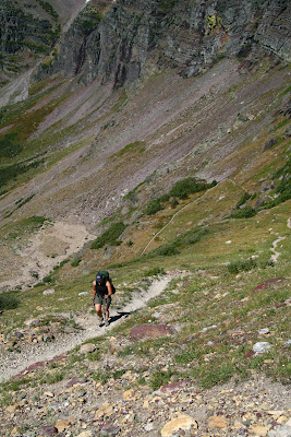
Not a huge climb (400 feet or so), but it would let us know how our bodies would respond after yesterday's punishment. We started up the switchbacking pass, just knocking out each straightaway we came to with surprising quickness. Before we knew it, we were cresting our first mountain pass of the day.

Jill is happy to finally have a descent

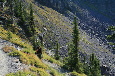
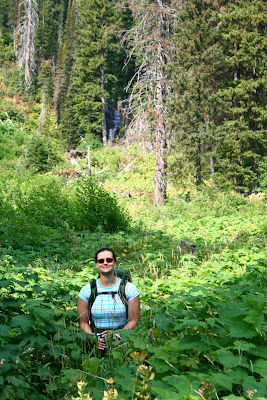
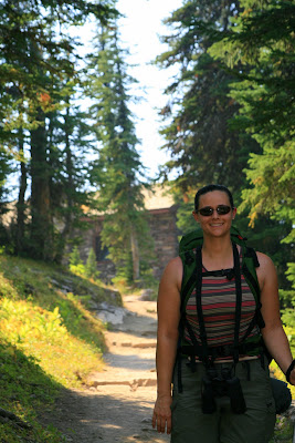
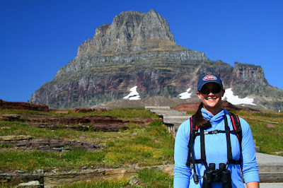
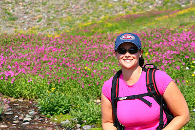
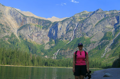
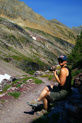
Jill taking in the views


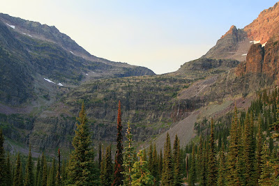
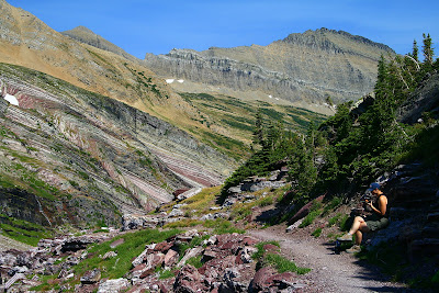
The back side of our first mountain pass

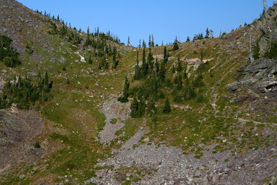
Blue skies are a welcome sight after several smoke haze filled days


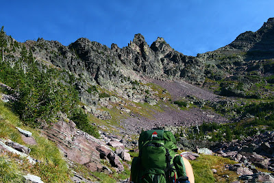
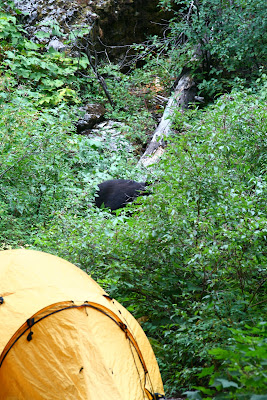
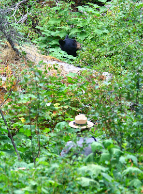
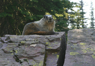
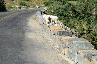
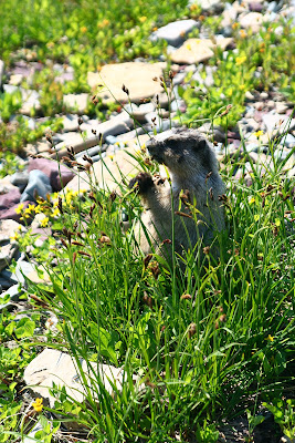
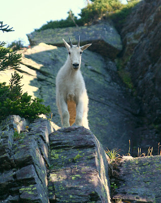
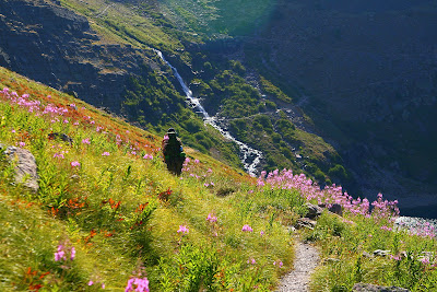
As we made our way around the trail etched in the side of the mountain, the views continued to improve. After a couple of miles, Lake Ellen Wilson would show itself but until then we'd enjoy the views from the trail, including some more wildlife.

This guy was hanging out on the trail, and was quite interested in us.


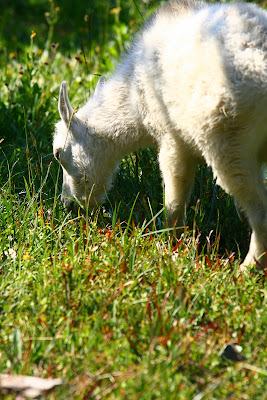
This guy was just around the corner from the little guy


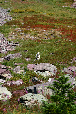
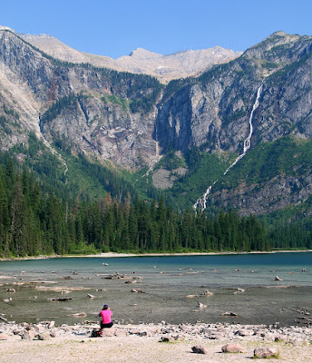
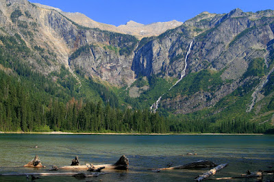
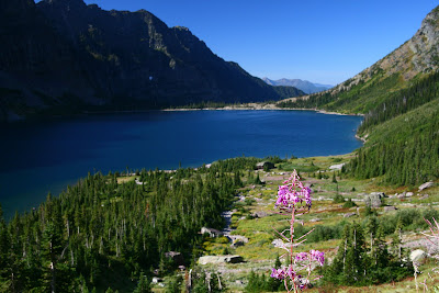
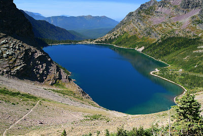
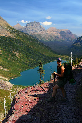
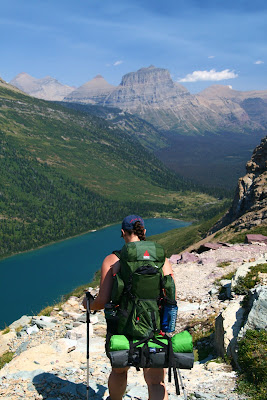
After about an hour, Lake Ellen Wilson came into view, and what a view it was. The turquoise water against the steep, rugged mountains was certainly a sight to behold. In this enormous glacial valley with more plunging waterfalls than you could count feeding the high alpine lake, the views were exactly what I had hoped to find.


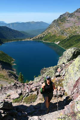
Jill gets the first view of Lake Ellen Wilson

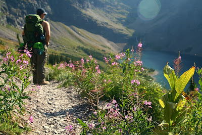
Lake Ellen Wilson, a high alpine treasure


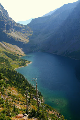
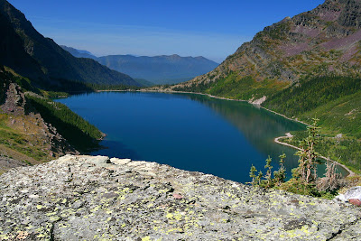
We could finally see the lake, but the deceptive size would mean we had a considerable amount of time just hiking around it. You can see in the pic above, on the far end what we would ultimately end up hiking over, Gunsight Pass. We pushed on, stopping often as every angle presented a new glacier, waterfall or scenic view.

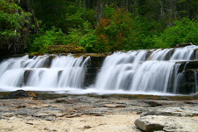
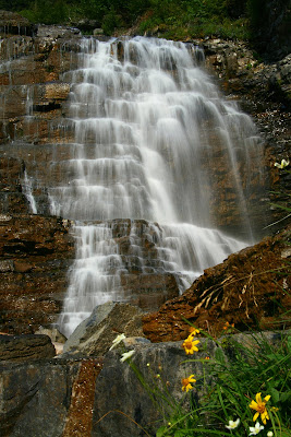
Finally as we approached the northern end of the lake, an enormous waterfall showed up in the distance. The trail was heading directly for it, so we agreed we would push on to the waterfall, then sit and have a quick snack as we gawked at our surroundings.

Jill heads towards the waterfall and Gunsight Pass


A good place for a timer shot


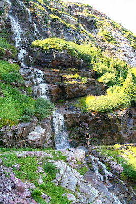
As we dropped to the end of the lake, it was apparent we'd be traveling pretty much directly through this waterfall we'd been gazing at for the last 1/2 hour. It was as beautiful up close as it was from a distance, pouring directly into Lake Ellen Wilson.


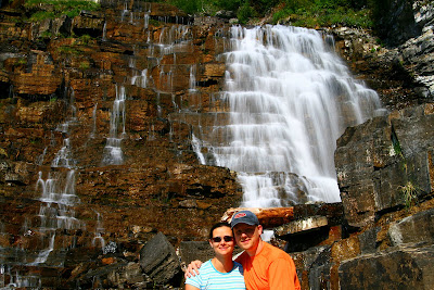
Here I am safely crossing through the waterfall

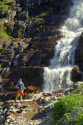
Jill does her waterfall spokes model pose


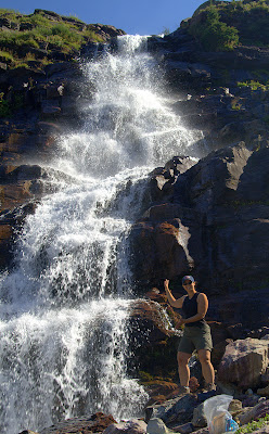
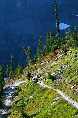
After some lunch, we had to face up to the next big challenge in our trip, climb up and over Gunsight Pass and the Continental Divide. The push up Gunsight Pass was brutally steep, climbing over 1,000 feet in just over a mile. The trail was switchback after switchback, which at times felt like a losing battle. Knowing this would be our last "real" climb of the day, we pushed a little harder and got up over the pass.


Looking back at Lake Ellen Wilson


Jill pushes up the switchbacks


I couldn't quit taking pictures of this place


Jill takes the final steps on climbing over her first named mountain pass


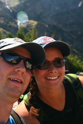
We posed for a shot at the top of the pass


Once over the top, it was time for lunch. We fired up the JetBoil and had some delicious spaghetti. I am constantly amazed at how good the Mountain House freeze-dried meals are. Maybe its that I'm starving and anything would taste good, but more likely its the added ingredient that we are normally eating them in places that few people ever see.

Jill is happy to get some lunch on the Continental Divide


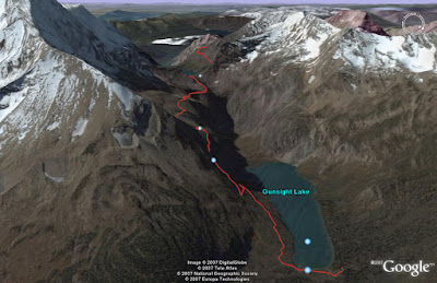
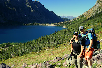
After lunch, we started the long descent to Gunsight Lake. It was about a mile over the pass, before the trail jutted out enough for us to get our first view of Gunsight Lake. Another majestic high alpine lake, this would be our destination for the night as our campsite would reside just on the northern edge of the lake.

Jill poses with Gunsight Lake in the background


Jill crossing a waterfall on the way to Gunsight Lake


Jill continues the plunge to Gunsight Lake


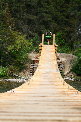
The descent to Gunsight seemed to take forever. From the first view of the lake, to the time we hit the edge of it had to be an hour. From the time we hit the first edge of it, it was likely another hour till we had reached the opposite end. At the end of the lake, we had to cross a suspension bridge that looked tame, but proved a bit unruly to cross with a big, heavy backpack. After negotiating our last obstacle, we had arrived at our destination for the night, and what a welcome site it was.

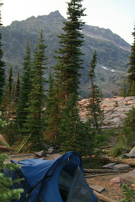
We were the first group that hadn't stayed the previous night to arrive, so we had 3rd choice of campsite (out of 7). We setup camp, hung our food, then headed to the glacially fed lake to bask in the sun.

I marched out into the lake, but got about knee deep before retreating a bit. The glacially fed waters were quite chilly despite the warm temps. After some easing, I was able to get myself adjusted and just sat in the lake neck deep soaking in the sun and the incredible views.

What a way to spend a Wednesday...
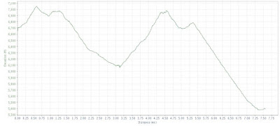
Day 2 Totals
7.56 miles
1,911 feet elevation gain


Wednesday, August 22, 2007

Glacier Backpacking Trip - Day 1

So after stuffing ourselves thoroughly the night before, we slept in a bit (7am) and then started laying out our gear we'd need for the next 3 days. We knew our packs would be heavy, and we knew the route would be brutal so I tried to optimize our weight as much as possible. I would take as many of the non-consumable items as possible, and let Jill take mostly consumable items so her pack would get lighter throughout the duration of the trip.

My pack held both our sleeping bags, the tent, the stove, my clothes and more pounds of camera gear than I care to admit. Jill had all the food, her clothes, our water and all the odds and ends that quickly add up to real pounds. We estimated our packs to be 25ish pounds for Jill's and probably 35-40 for mine. Heavier than we needed, but as Jill says "If I want to haul 35 lbs of Snickers bars up the mountain then I ought to be able to." I tend to agree with her.

So for our west to east journey across Glacier, we headed to Lake McDonald to start our journey. We opted to just park at the start and catch the shuttle after our trek rather than setup the shuttle so the car would be waiting for us at the end.

Jill looks eager to start the 7.5 mile uphill slog


We got started on the trail around 9:30am, late enough that the horse traffic on the trail was in front of us, meaning we'd be force to deal with the "trail apples" left behind for us. The first couple of miles offered no warm up, as the trail climbed steadily and steeply away from Lake McDonald before leveling off a bit for miles 2 - 4. After a couple of hours of steady workman like efforts, we came to the first junction and set down for some lunch to give us some energy for the final half of the day's climbing.

Still looking pretty happy even after a whole lot of climbing


After lunch we pressed on, encountering quite a few people on the way back down. Most we talked to had stayed at the Chalet, a $255 per couple per night experience, in a high alpine environment. Most had either hiked up "the easy way" or had taken horses up. Everyone seemed quite eager to continually tell us "its all uphill" as the zoomed by on the 7.5 mile descent.

As we got within a mile of the chalet, we could see its dramatic setting up above us. We still had a steep mile of climbing to reach it, but the scenery was getting better and our destination (for day 1 at least) was in sight.


Rounding the corner to the last push, the chalet was but steps away. Jill posed for a quick picture near the arrival and then we headed up to this oasis on the mountainside. We were told meals were available, even to us poor campers, but the real delight was finding out they had $1 candy bars. I'm not much of a fan of the chocolate, but after a long day and a 600 calorie dinner a Butterfinger tasted like heaven.


Just about 1/4 mile past the chalet was our campsite. We were the 3rd group (out of 4) to arrive, so we grabbed one of the two available sights and dropped those heavy packs as quickly as we could. We setup camp, hung our food up on the bear poles and then just relaxed around camp.

Home, sweet home - for the night at least


Jill reads while I try my best at an artistic shot


After arriving at camp, we were a little surprised to see that despite being in the back country, it was somewhat "group" camping. The 4 sites at Sperry were pretty closely put together, with our site being Site #1 and only about 10 or 15 yards from Site #2. 3 and 4 were close together, but at least 100 yards from us. The other difference from our other experiences was the group food storage and cooking areas. Normally, each site has its own area for cooking and storage area. It wasn't a big issue, and we actually enjoyed talking with the two guys staying in site #2. We traded some stories and just talked in general before retiring to our respective campsites for sunset.

Not a bad place to spend the night


So day 1 was in the books, and after our brutal first day, the days should get progressively easier (although far from easy days). So the gaudy numbers for day 1 stacked up as:

7.66 miles
3,775 feet climbed (300 descended)
3:23 minutes moving time (2.3 mph avg)


Don't speed through Glacier National Park

Facing the daunting task ahead of us, Jill & I decided to "fatten up" the night before heading into back country for the next 3 days. We left our campground and had about 10 miles of driving through Glacier National Park before getting out of the park and heading to Columbia Falls.

If you've ever been to a National Park, you know that during peak times you always come up on slow traffic. Glacier is no exception. So as we drove along, it didn't take us long to catch the slow mover in front of us. That proved to be OK though as a Glacier Park Ranger (read traffic cop) pulled in behind us shortly after that. We had seen numerous people being pulled over for speeding and traffic offenses already in the park, so we decided we'd be on best behavior.

Things got better when the ranger turned into the Lake McDonald parking area, presumably just to do a quick sweep, but we were at least out of his sights for now. Still stuck behind the slow moving Chevy Blazer, I glanced up in my rear view as I see a group of 3 guys on motorcycles racing up behind us. They are on sport bikes, and the lead guy grabs a big handful of brakes while standing and looking around us in a perturbed fashion.

The lead guy swings over to the yellow line a couple times, looking generally pissed off at being slowed down, as the other two ride side by side about 20 feet back from him. While the lead bike is assessing the slow moving cars (us included) in front of him, I notice the park ranger racing up behind the three bikes. He's obviously seen them blow by the parking lot and he was after them, but by the point he catches them they are going the speed limit behind us.

A mile or two of 40mph road goes by, all while the front biker is getting more and more agitated. He's riding our bumper and swerving toward the yellow line, all the while never realizing that the ranger is sitting back behind him.

Finally he's had enough. He jumps across the double yellow no passing line on a blind corner, guns it and is gone. He had to have ratcheted up the speed to around 70mph as he quickly vanished from sight. All the while I'm cheering and laughing as I know the ranger is behind him, but evidently he doesn't. I look back to see his two buddies lean down to call him on their helmet microphones to tell him what idiotic thing he has just done. All the while this is going on, the park ranger still sits silently behind the group.

And then he lights up the bar, and blows by us in pursuit....

I'm in full laugh mode now as you never ever get to see people like this get caught. They always pass when they shouldn't and you always wish there would be a cop sitting around the corner. Well this time he was sitting right behind with a bird's eye view of the infractions.

Couple of miles of road pass by and then we turn a corner to see the two wheeled terror pulled over in a parking area with the ranger approaching him. The motorcycle rider already had his helmet off, wallet out and was looking a bit miffed with the whole situation. I really, really wanted to give him a little "beep, beep" horn as I passed but figured better to just let it go, he was in enough trouble as it was.

Tuesday, August 21, 2007

Glacier - Precursor to the journey

When you last left our intrepid travelers, they were facing the daunting decision of what to do about their dashed back country adventure plans. Do they alter the route totally or face the brutal route from Lake McDonald to St. Mary Lake?

Well after a lot of deliberation, I decided that IF (and it was a big if) the campsites we wanted were still available, that we would buck up and do the reverse route that we had originally planned. We had a tiny window as there was only one opening at both the campgrounds we needed, and if either booked up we'd have to totally scrap plans and find something altogether different.

So the next morning we got up at 6:30 and headed to the back country permit office for the 7am opening. We arrived 3rd in line, but with a bit of luck we found 3 rangers so we were in the first line of people. We quickly spilled out our agenda while the rangers and other two sets of campers took notice and commented on how tough that route was. We never do anything the easy way...

So we had our permits secured for the following day, but we would still had all day to fill so we decided to warm up our legs with some day hikes. On Judy's recommendation, we started with the Trail of the Cedars which was a quick 1 mile hike around some of the oldest trees in Glacier National Park.


After that we made our way up Going to the Sun Road to the visitor's center to check out another Judy recommended trail, the trail to Hidden Lake. The hike starts at the visitor center and heads up steadily from there to the overlook above Hidden Lake.


On our way up we got to see more of the local animal crowd, including mountain goats, bighorn sheep, and a hungry marmot chomping away. Despite the pretty high traffic, the animals seemed relatively unaffected by the people and the constant shutterbugs snapping pics, myself included.


After Hidden Lake, we headed up to the NE side of the park to check out the Many Glaicer area. In what is typically the most photographed area of the park, we were pretty much limited to a quick drive through as the haze had finally caught up to us that day and the views were quite compromised.

After grabbing some dinner, we decided to do one final 4 mile hike up to Avalanche Lake. Avalanche Lake is a high alpine lake that sits a huge three quarters bowl with numerous waterfalls feeding this turquoise colored lake. We made pretty quick work of the trail, and then enjoyed the views before heading back down to get some rest as tomorrow would be a big day. A very, very big day...