So Sarah & Molly (of ex-coworker Chris & Molly fame) showed up at my house right about 7a.m. to set off for a long road ride. Our route would take us East out of Longmont to 75th St., or "Road Biker Rd." as I call it, where we would head North. The route would be mostly flat until we started heading up to Carter Lake, which I thought would be nice as to give my legs a chance to wake up before starting the climbing. Looking at the route via Google Earth, it looked to be about 50 miles roundtrip, with several bail-out points and options to add more mileage if we felt good.
So off the 3 groggy gringos went spinning down the road. We were spinning along nice and easy making our way through a lot of countryside none of us had ever ventured past before. We made pretty quick work heading north, reaching the turn for Carter Lake pretty quickly. As we started the approach towards Carter Lake, which is nestled in the foothills SW of Loveland, the road turned upwards. In the final stretch, a series of pretty steep switchbacks led up to the dam. I hopped in behind a couple of older guys and thought I'd be content to spin behind them, but I quickly had to hop out and make a run at it as it was more effort to ride their speed than my own.
We regrouped on top of the dam, grabbed some energy bars and Gatorade and continued on down the road. We quickly hit the big descent of the day, a steep, long hill that pushed our speeds up into the mid 40s.
Turning away from Carter Lake, we came to the first decision point of the day. Left turn meant 60ish miles. Right turn meant a little less than 50 miles. We did a status check in the group and got the thumbs up from everyone, so we took the left and motored up the road towards Loveland & Ft. Collins. We found a couple more substantial climbs, and did a lollipop type loop across Hghwy 34 and then back.
Molly had only been on her road bike 3 or 4 times previous to this, and the positioning was starting to take a toll on her by the 35 mile mark. I dropped back and tried to keep her out of the wind as much as possible to ease her efforts. The 25 miles heading back south consisted of rolling hills, and when the gas tank is empty the hills all seem much bigger. Molly did a great job of sitting on our wheels and grinding up the hills, saving energy when she could.
After a couple breaks to get off the bikes and into the shade, we started to see the home stretch. Temps were rising and all the Sunday drivers were starting to come out in droves. Thankfully our final 8-10 mile stretch was wide shoulders and bike lanes, so we could avoid the perils of traffic for the most part.
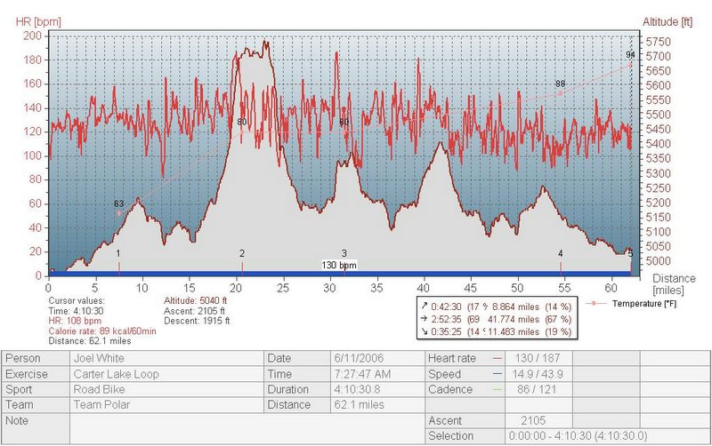
We ended up putting in 62.1 miles, in a little over 4 hours of riding. Sarah & I upped last weekends 52 mile ride by 10, and will need to keep adding distance each weekend to prepare for the upcoming MS150 ride we'll be doing July 8-9. For me, a nice, easy day in the saddle. I got to do some lower zone (130 heart rate avg), endurance type riding which is something I really need. When I ride alone, I tend to do 80% type riding so I welcomed the chance to back off the pace and just get some good, base type mileage in my legs.
You can see in the graph below(the red line that is more linear) how the temperature jumped 30 degrees over the course of our ride. At mile 7 it was about 63, then by mile 62 it was 94. I was sure glad to be done with the ride and out of the heat. My big regret is my dumb crash that kept me off the mountain bike last weekend, but there doesn't seem to be any lasting impacts so hopefully this weekend I can get the Yeti out for some much needed singletrack miles.
Legend:
Red, spiking line is heart rate curve
Red outlined white area is elevation curve
Red line graph is temperature curve.
1 comment:
This is my favorite post of all. You and Sarah are hard core, but I'll ride with you any time I get the chance (interpretation: when I am feeling especially confident in my fitness level)!
Post a Comment